08 Abr 2021 Request for Proposal (RFP): Professional Surveyors Services

The Department of Natural and Environmental Resources, through the Puerto Rico Coastal Zone Management Program (PRCZMP), is seeking applicants to complete an assessment and update of the Island-wide Official Reference System for delineations of the Coastal Public Domain Lands in the Maritime-Terrestrial Zone (“bienes de dominio público marítimo-terrestre”, in Spanish). The System provides the legal and regulatory framework for the administration of the maritime-terrestrial public domain, as well as access to essential technical information about tides, geomorphology, vegetation and a network of geodetic benchmarks that enable any professional land surveyor to initiate the delineation of the boundary between public lands and private properties for any given coastal parcel.
Act No. 151 of June 28, 1968, Docks and Ports Act of 1968, 23 L.P.R.A. §§2101, establishes that «the maritime- terrestrial zone means the space of the coasts of Puerto Rico that bathes the sea in its ebb and flow, where the tides are sensitive, and the largest waves in storms [reach] where the tides are not sensitive, and includes land reclaimed from the sea and river banks up to the site where the tides are navigable or become sensitive«.
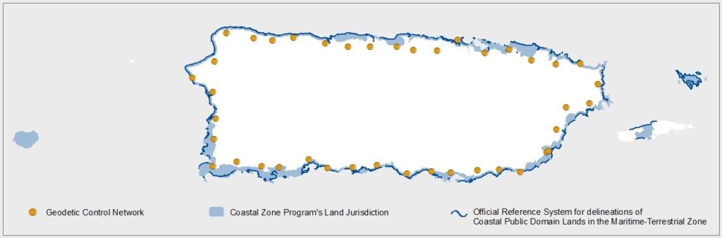
The DNER has established a network of 40 horizontal and vertical controls around the Island of Puerto Rico as part of the process of developing the Official Reference System for the demarcation of the Maritime-Terrestrial Zone (ZMT, in Spanish). Individual controls are located approximately 10 km apart from each other, and 5 km from the coast, in fully accessible places. The purpose of this network was to create uniformity when identifying and evaluating the ZMT boundaries. The control network is georeferenced in NAD83 (2011) Epoch 2010.00, a system mandated by law to carry out surveying works in Puerto Rico (Law 264 of November 16, 2002). The vertical system is georeferenced to the PRVD2002.
It is recommended that the Official Reference System should be updated at least every 5 years, or after any event in which coasts undergo major geomorphological changes. During the years 2017 and 2018, our coasts experienced the impacts of Hurricanes Irma and María, Winter Storm Riley, and multiple winter swells that affected the extension and configuration of many beaches. At the end of 2019 and throughout the year 2020, the Southwest of Puerto Rico witnessed the impact of multiple earthquakes which may have affected the position of the geodetic benchmarks due to vertical displacements. Therefore, the network must be revised.
Three main services of a professional land surveying firm are requested:
1. UPDATE THE OFFICIAL REFERENCE SYSTEM FOR DELINEATIONS OF THE COASTAL PUBLIC DOMAIN
a. Review the webpage Official Reference System for delineations of the Coastal Public Domain administered by DNER-PRCZMP and provide recommendations.
b. Calibrate and validate the Geodetic Network of 40 horizontal and vertical controls funded and maintained by DNER-PRCZMP.
c. Maintenance, replacement or relocation as needed of any displaced geodetic benchmark of the network, lost or impacted by Hurricanes Irma and María and associated debris removal or construction work.
d. The field study also delimits other topographic and geographic features closely related to the ZMT, such as beaches and dunes.
e. Surveying drawings.
2. EVALUATION OF NEW ADVISORY FLOOD ELEVATION MAPS ADOPTED BY FEMA AND PRPB 2018
Flooding of communities and damages to critical infrastructure were among the worst impacts caused by Hurricanes Irma and Maria (2017). As a result, FEMA and the Puerto Rico Planning Board (PRPB) – as the State Flood Plain Management Agency – conducted a rapid review of flooding marks compiled by the USGS, the Academia and field validation efforts, among others. Imagery captured by NOAA was used to evaluate flooded areas during the hurricanes. The Advisory Base Flood Elevation Maps have been published by the PRPB. A new “Coastal AE Zone” category was included as part of the FEMA FIRM maps. PRCZMP also needs to review the effects on the definition of boundaries between zones: VE and AE resulting from the use of the NAVD 88 in Puerto Rico, considering that there is a more accurate vertical datum for Puerto Rico (PRVD 2002). The consulting firm will provide support to DNER-PRCZMP through this important analysis process.
3. A PUBLIC NOTICE ABOUT THE INTENTION OF THE WORK PROPOSED HERE WILL BE REQUIRED
It will be a requirement to publish the intention of the works in a newspaper (with island-wide distribution).
A. Proposal content:
The proposal should not exceed 10 pages in length. Pages in excess of 10 will not be reviewed. The proposal should address the following items in a concise, and yet complete manner and offer all the necessary information for the evaluation of the proposal:
(1) Content page:
-
- Project title
- Project team – Include name, title, affiliations and contact information of the project leader and key personnel.
- Project Cost- Including deliverables (insurance policy, progress report, etc.)
- Abstract- Describe briefly how the project is going to be completed and any important details.
(2) Proposal Narrative:
-
- Goals and Objectives
- Methodology – Outline project design and describe tasks and processes to be completed to meet the project objectives.
- Relevant Experience -Briefly describe relevant experience of the project leader and partners.
- Project Schedule – Dates of starting and finishing project, as well as a detailed time frame regarding reports, milestones and/or specific activities.
B. Geodetic Control Network:
C. Eligibility:
Surveyor or surveyors firm with a license and current membership of the College of Engineers and Surveyors of Puerto Rico can submit proposals.
D. Report:
- Submit quarterly progress reports, as well as additional reports, if applicable, with each invoice.
- Submit a final report summarizing the following:
- Methodology used to implement the project (monumentation and GPS observations)
- Data summary, surveying plans and findings (if applicable)
E. Available funding: $90,000
F. Estimated Time frame to complete the tasks: May, 2021 through March, 2022.
G. Evaluation Criteria for Proposals:
| CRITERIA | EVALUATED ITEMS | SCORE |
| Working Plan | Ability to perform the required works, a comprehensive work plan, including detailed itinerary. | 55 |
| Compliance | Compliance with state regulations and requirements (license or certifications to practice your profession in Puerto Rico, DUNS Number, ASG registration) and federal standards . | 10 |
| Experience | Previous experience. | 20 |
| Budget justification | Budget narrative (e.g. personnel, supplies, insurance policy, survey, public notice, etc.). Any proposed budget exceeding $90,000 will not be considered. | 15 |
H. Submittal: All proposals must be received by May 10, 2021. Applicants should submit both an electronic and hard copies of their proposals as follows:
-
- Electronic – PDF or Microsoft Word® documents must be sent to pmzc@drna.pr.gov and nviera@drna.pr.gov
- Hard copy – Two hard copies must be delivered to:
Puerto Rico Coastal Zone Management Program
Department of Natural and Environmental Resources
San José Industrial Park
1375 Ave Ponce de León
San Juan, PR 00926
I. Proposal Evaluation Process: Proposals that meet all the requirements of this RFP, will be evaluated by a review team from DNER. Proposals will be evaluated on the applicant’s demonstrated ability to calibrate and validate the Geodetic Network of 40 horizontal and vertical controls funded and maintained by DNER-PRCZMP. Process to evaluate the proposals will be:
a. Comprehensiveness of the proposal.
b. Individual or firm’s experience on similar projects, regarding such factors as quality of work, cost control, and ability to meet schedules.
c. Adequacy of technical staff, as demonstrated by experience, education, and potential project role.
d. The contractor understands the services required by the Program.
e. Proposed costs.
f. Organization and scheduling of the project requirements.
g. Knowledge and ability to comply with federal procurement standards and grant regulations.
h. Professional quality of the project proposal: conciseness, clarity, and thoroughness of presentation.
i. Project manager accessibility.
j. Ability to complete project in a short period of time.
J. Proponent Selection Notification: DNER-PRCZMP will notify the selection not later than Monday, May 31, 2021.
K. Other Special Conditions:
- This RFP does not commit the PRCZMP to award a contract, to defray any costs incurred in the preparation of a proposal pursuant to this RFP, or to procure or contract for work.
- All proposals submitted in response to this RFP will become property of the PRCZMP and will be considered public documents, and as such they may be subject to public review.
- The PRCZMP, at its sole discretion, reserves the right to cancel this RFP for any or no reason, in part or in its entirety, including but not limited to: section schedule, submittal date, and submittal requirements. If the PRCZMP cancels or revises the RFP, all applicants will receive a notification advising the cancelation or revision of the RFP.
- The PRCZMP reserves the right to request additional information and/or clarifications from any or all potential contractors participating in this RFP.
- Announcement of the selected contractor, contract awards, and all data provided by the PRCZMP shall be protected from public disclosure. Consultants desiring to release information to the public must receive prior written approval from the PRCZMP. The PRCZMP, at its sole discretion, shall determine the release and disclosure of information related to this RFP and any final work products as a result of it.
L. References:
- DNER Official Reference System for delineations of Coastal Public Domain lands in the MaritimeTerrestrial Zone
- PRPB – FEMA Advisory Base Flood Elevation Maps
- NOAA ORR ERMA Caribbean
Related Documents: